終於我們到了新的島嶼!雖然我只在東引一天,可是想po的內容太多了,至於過了這麼多時間。
這次我想要把莒光介紹一下。莒光在南竿,北竿的南邊。搭船只要花一個小時少就會到了。什麼機場都沒有,所以除了從南竿搭船以外沒有辦法去莒光。
莒光包括兩座有人的大島,西莒和東莒,還有一些無人的小島。因為離中國不遠,所以站在西莒長樂也看得到。
我原本打算住兩夜,可是因為北風很強烈地吹過來了,四月七號船都沒開,結果我住多一夜。三夜都在東莒住。
Well, we've left Dongyin, and we're now in Dongju. Where is Dongju? Dongju--along with its neighbor Xiju and some other unpopulated small islands--is south of Nangan, the main island in Matsu. It's close enough to Changle in China that you can see it. To get to Dongju, I had to take a boat to Nangan, then a different boat to Dongju. The map below is all in Chinese, but you can still get some idea of the lay of the land. The right island is Dongju ("dong" means east) and the left one is Xiju ("xi" means west).
滞在期間が一日しかなかったにもかかわらず東引の紹介がめっちゃ長くなってしまった。今日はやっと次の島に移ることになる。
今回は「莒光」という列島に訪れる。私は東引を離れて南竿で船を乗り換えて、東莒という島に着いた。(東莒は「とうきょ」と読めるだろう。全然大都会の東京と違うのに。中国語は「ドンジュ」みたいな発音になる。)
莒光島々の中に、有人島は東莒と西莒二箇所だけ。周りの小さな島は全部無人島。私は東莒に三泊した。元々は二泊のつもりだったが、帰る日に北風が強くなって、船は全部出ないことになってしまった。そのおかげでもう一日遊べた!

東莒的猛沃港
Here's Mengwo harbor in Dongju.
東莒の猛沃港(日:もうよく、中:モンウォみたいな感じ)


Chiang Kai-shek is not liked by the birds.
蒋介石は島の鳥に嫌われている。

The first thing I did was rent a scooter and go around the island's north road. On the way I passed a reservoir.
着いてから早速バイクを借りて、復興路を回った。途中でこの福正水庫(貯水場)があった。


我到了飯館,有一件事嚇了我。服務生穿迷彩服!他就是一個軍人!我問他為什麼在飯館當服務生,其實我不太了解可是他跟我說軍人有時候要幫島民的忙。好像是他們的一個任務。我猜有可能是為了把島民跟軍隊的關係弄好軍隊決定要這樣做。後天我也遇到一樣的軍人在郵局。他也在那裡幫忙!(到底什麼時候出門訓練!?)
It was already past noon, so I went back to the main town of Daping for lunch. Daping is the most recent of the towns on the island, and is therefore the least interesting since it has more concrete monstrosities and fewer traditional homes than the other towns. The vast majority of people live in Daping though because it's close to the harbor. While it is lacking in traditional homes, it is well-populated by cats, so it's not without its charms.
Strangely enough, when I went to eat lunch, my order was taken by a young guy in camouflage gear. It turned out that he was actually a soldier! I still don't quite understand why, but he made it sound like moonlighting in this local restaurant was part of his duty while posted on the island. Perhaps it's something the military does to keep relations with the islanders on good terms? I actually saw the same guy later on during the week working in the post office.
間も無く昼間になって、昼飯を食べに大坪村に戻った。大坪村は猛沃港に近くて、島の一番大きな村落だ。一番新しい村でもあるので、正直あまり面白い伝統的な建物はない。でも猫はめちゃくちゃ多い。
食堂に入ってみたら、変な風景を目にした、迷彩服を着ている男性は接客で働いていた。聞いてみたら、実際に軍人だった。よく分からなかったが、東莒に派遣された軍人の仕事の中に、島民を手伝う仕事も含まれている様だ。同じ人はその後日郵便局でも見かけた。軍人として来ているはずなのに、だいたい雑用の仕事しかやっていないじゃないか。


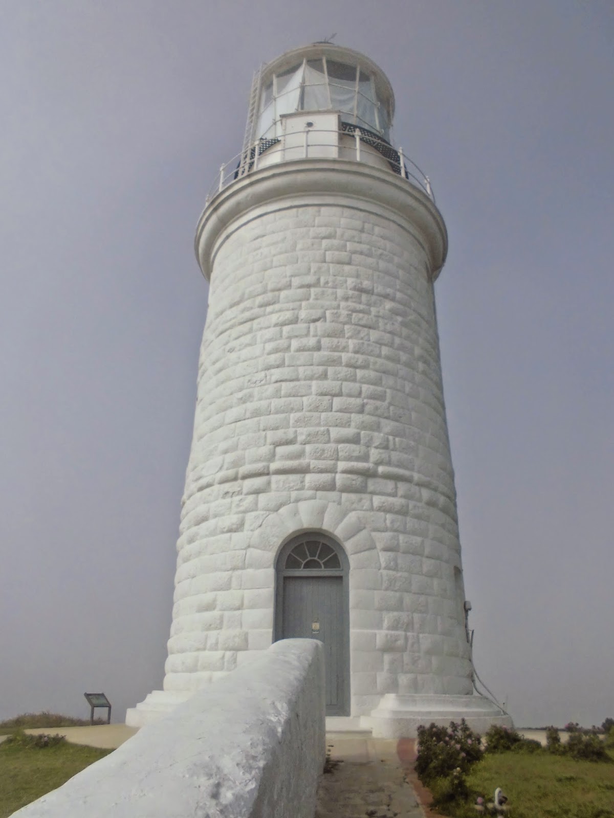
After eating lunch, I went to check out the lighthouse on the island. Dongju's lighthouse, like the one on Dongyin, was designed by an English guy. It was built as part of the unequal treaties that the Qing Dynasty signed with various western powers in order to help out western ships navigating through these waters.
昼ごはん終わったら早速灯台を見に行った。東莒にも東引と同じく灯台がある。両方ともはヨーロッパ列国と清朝の間で結ばれた不公平条約の下で建てられたから、両方ともイギリス人の計画によって造られた。東莒の灯台の方が高くて、周りも広々とした丘の上になっている。


The lighthouse is known both as the "Dongju" lighthouse, and also the "Dongquan" lighthouse because the name of this island group was changed a couple of decades back. The two big islands, Dongju and Xiju, used to be called "Dongquan" and "Xiquan", "East Dog" and "West Dog". Together they were the "White Dog" islands. The image was of two dogs playing in the water just outside the mouth of the Minjiang river. The image is a cute one, so really, I think they should change the name back.
この莒光列島は元々「白犬列島」だった。閩江川の入江の沖にある二つの大きな島は海で遊んでいる犬に例えられた。というわけで、以前は東莒は「東犬」だった。実は、犬の字が入っている名前の方が可愛いから、この名前を復活させたらいいと思う。


A map of northern Taiwan. The place names are the Japanese versions, so it must be from between 1895 and 1945.
台湾の北部の地図。日本語の名前が載っているので、日本時代の台湾みたい。

"Taihoku" is modern day "Taipei"

A map of all of the lighthouses in Taiwan
台湾の灯台。全部行きたい。

This wall stretches from a building nearby to the lighthouse. It's purpose is to block the wind. It's kind of low-built, but that's because it wasn't built to protect people, it was built to protect oil lamps. One could carry an oil lamp and not worry about the wind blowing it out thanks to this wall.
この壁は現在資料館になっている建物と灯台の間に建っている。電灯のない時代には、油のランプを使用したけど、もちろん風に吹かれたら消えてしまう。この壁は暴風の働きをする。ランプを守る為に造られたので、人の腰ぐらいの高さしかない。


The lighthouse is made out of granite apparently.
この灯台はなんと花崗石でできているそうだ。


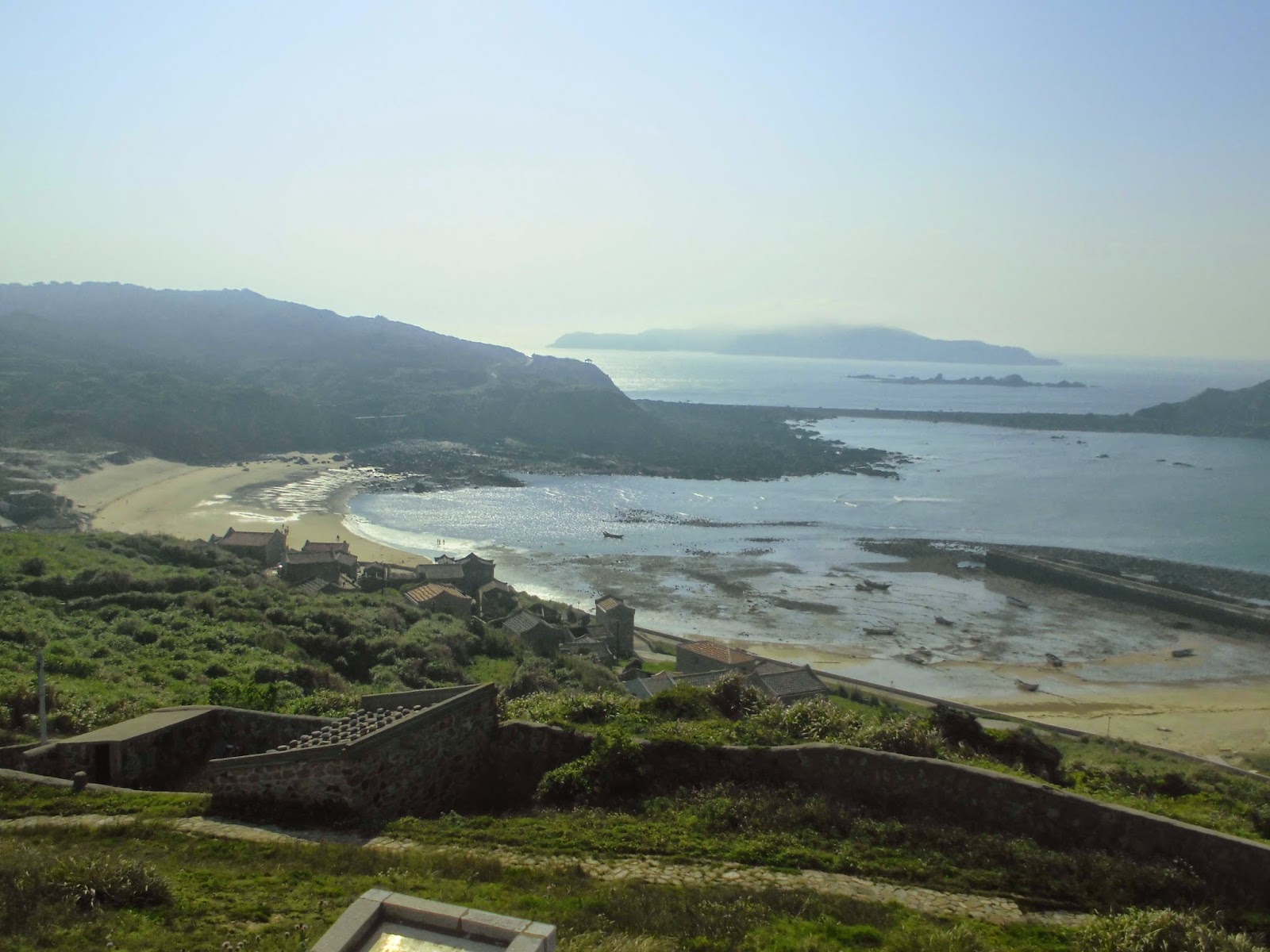
Below the lighthouse is Fuzheng village.
灯台のしたの福正村


The island below is connected to Dongju during low tide. If you look on the map above, you'll see that they've actually drawn it as a totally separate island. (It's the island just north of Dongju.)
向こうの半島は「犀牛島」という。上記の地図を見たら、本当に完全な島になっている。干潮の時しか東莒に繋がっていない。

灯台に手紙を送ってみる?

A device to keep the shutters open.
鎧戸を止める道具


There're some abandoned military buildings in the area, so we'll check those out next time.
灯台の周りに廃墟となった要塞があるので、次回見てみよう!
No comments:
Post a Comment